
EFFIS wildfires (Copernicus)
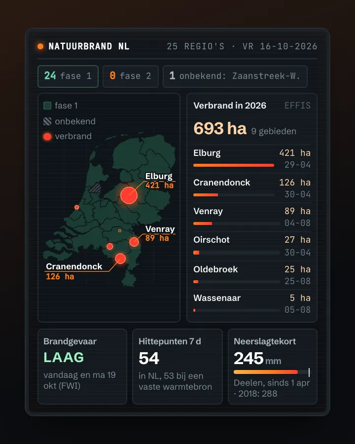
The European Forest Fire Information System maps fires in natural areas from satellite imagery (MODIS, VIIRS and Sentinel-2). For each burnt area: date, area in hectares, municipality, the outline as a polygon, what was growing and how much lies in Natura 2000. For the Netherlands 53 areas since 2003, the largest near Deurne (April 2020, 649 hectares) and Elburg (April 2026, 421 hectares). Plus an open map service with the fire danger for the coming days (Fire Weather Index) and today's hotspots.
The largest wildfires in the Netherlands according to EFFIS: most Deurne, April 2020 (649 hectares), then Elburg, April 2026 and Ede, April 2014
The largest wildfires in the Netherlands according to EFFIS, 2003–2026, in hectares. Total: 3,049; the largest 12 of 53 categories are shown. Deurne, April 2020 is 21% of the total. All 53 areas EFFIS has mapped in the Netherlands since 2003, 3,049 hectares together. Municipality as EFFIS names it. Small fires are missing.
Burnt natural land in the Netherlands mapped by EFFIS: 330 hectares in 2025, 80% more than in 2018
Burnt natural land in the Netherlands mapped by EFFIS, 2018 – 2025, in hectares. The highest point was 2020 (822).
What you can build with it1
What can you do with it?3 ideas
Wildfires on the map
Draw the outline of every burnt heath or forest on a map; the response contains the polygons as GeoJSON.
Compare fire years
Add up the hectares per year: 2020 (Deurnese Peel) and 2026 stand out.
Drought and fires
Put the fire dates next to the rainfall of the weeks before (KNMI) and next to the fire danger from the map service.
How to process it2 steps
Request the burnt areas
One call per country, no key. The response has count, next (next page) and results with per area firedate, area_ha, commune, province, shape (MultiPolygon) and land cover in percent.
https://api.effis.emergency.copernicus.eu/rest/2/burntareas/current/?country=NL
Fire danger as a map layer
The WMS has layers for the Fire Weather Index and its components (mf010.fwi, .ffmc, .dmc, .dc, .isi, .bui), hotspots (viirs.hs, modis.hs) and burnt areas (effis.nrt.ba).
https://maps.effis.emergency.copernicus.eu/effis?service=WMS&request=GetCapabilities
Interesting combinations


From hotspot to burnt area
FIRMS sees the fire while it burns (375-metre points), EFFIS measures the burnt area afterwards.

Which nature burnt?
EFFIS already gives the share in Natura 2000; with the PDOK polygons you see which area it was.
Did the fire service raise the phase beforehand?
The wildfire risk per safety region is only shown as the current state on brandweer.nl; store it daily yourself to compare it with the fires.
Similar sources
- NASA FIRMS (fires)
Hotspots per satellite pass, not the burnt area.
- GW
What to watch out for
- Only the larger fires
EFFIS mainly sees the larger fires; for the Netherlands the list runs from under a hectare to 649 hectares, but there are only 53 since 2003. Many small heath fires are missing, so this is not a complete fire statistic. A year without an area means: nothing mapped.
- Earlier years sparse
Before 2018 there are only four areas for the Netherlands (2003, 2011, 2014, 2015). Since then there are more per year; whether that is because of more fires or better imagery, EFFIS does not say. Compare years with care.
- Municipality and area are names
commune and province are names (Bergen (NH.), Veluwe), not CBS codes. Link via the outline to the municipal boundaries.
APIREST (JSON, Django REST Framework) + OGC WMS 1.1.1 · read 16 Oct 2026
No key or account (tested). No robots.txt on the EFFIS hosts. tested
burnt areas in the Netherlands (2003–2026, together 3,049 ha); across Europe and surroundings 129,710 (16 Oct 2026) tested
jsonpngkmlgeotiff
Base URL
https://api.effis.emergency.copernicus.eu/rest/2
Endpoints 3
- GET
/burntareas/current/Burnt areas (mapped from satellite images) with date, area, municipality, region, shape and land cover. Filter on country, date, area, geometry. - GET
https://maps.effis.emergency.copernicus.eu/effis?service=WMS&request=GetCapabilitiesMap layers: mf010.fwi (Fire Weather Index) and sub-indices ffmc, dc, isi, bui; hotspots viirs.hs and modis.hs; burnt areas modis.ba.poly(.today/.week/.month/.season/.<year>) and effis.nrt.ba. - GET
https://maps.effis.emergency.copernicus.eu/effis?service=WMS&request=GetMap&layers=mf010.fwi&time=JJJJ-MM-DD&…Map image of a layer for a day (ISO 8601 time dimension); formats png, jpeg, tiff, svg, kml, pdf.
Filtering tested
Django filters as query parameters: <field>, <field>__gte, __lte, __in, plus ordering.
Parameters 8
country / country__in | Country, e.g. NL; several with country__in=NL,BE. | tested |
firedate / firedate__gte / __gt / __lt / __lte | Fire date; a full date-time is required (2025-01-01T00:00:00). A date only gives 400 'Enter a valid date/time.' | tested |
area_ha__gte / __gt / __lt / __lte | Area in hectares (NL ≥ 100 ha: 7 areas). | tested |
lastupdate / lastupdate__gte … | Last update of the area: handy to track changes. | from the description |
province | Region as EFFIS names it (Veluwe, …), not a code. | tested |
intersects / contains / contained / covered | Spatial filters (in the filter form; not tested by us). | from the description |
ordering | Sort, e.g. ordering=-firedate (newest first) or firedate. | tested |
limit / offset | Paging; the response has count, next and previous. | tested |
Fields per burnt area 8
| Name | Type | Meaning |
|---|---|---|
id | tekst | Id van het verbrande gebied |
firedate | datetime · lokale tijd met offset (+02:00) | Datum (en tijd) van de brand |
area_ha | tekst (getal) · ha | Verbrand oppervlak |
commune / province / countryful | tekst | Gemeente, regio en land (namen, geen codes) |
broadlea, conifer, mixed, othernatlc, agriareas, artifsurf … | tekst (getal) · % | Aandeel per soort landbedekking (loofbos, naaldbos, gemengd, overige natuur, landbouw, bebouwd) |
percna2k | tekst (getal) · % | Aandeel binnen Natura 2000 |
shape / centroid / bbox | tekst (GeoJSON als Python-dict) · WGS84 | Vorm, middelpunt en omhullende |
lastupdate | datetime | Laatste bijwerking van dit gebied |
Limits and pitfalls
- No documented limit. Without limit all 53 Dutch areas came in one page; for Europe (129,710) always paginate with limit and offset. tested
- Numbers are strings ('12', '100.00000000') and shape, centroid and bbox are Python dicts as text (single quotes), not real GeoJSON: replace ' with " or use ast.literal_eval. tested
- Unknown parameters are ignored (?year=2025 and ?page=2 simply returned all 53). Other paths such as /rest/2/ return 404. tested
- The 'next' link starts with http:// instead of https://. tested
- Not complete: before 2018 there are only four Dutch areas. Very small ones are included too (area_ha 0 and 1): filter on area yourself. experience
- The WMS time dimension has a fixed default (2021-01-01) and no 'latest' date: always pass time. experience
Try it HTTP 200 · 9,151 ms · 16 Oct
https://api.effis.emergency.copernicus.eu/rest/2/burntareas/current/?country=NL&ordering=-firedate&limit=3
{
  "count": 53,
  "next": "http://api.effis.emergency.copernicus.eu/rest/2/burntareas/current/?country=NL&limit=3&offset=3&ordering=-firedate",
  "previous": null,
  "results": [
    {
      "id": 646790,
      "centroid": {
        "type": "Point",
        "coordinates": "…"
      },
      "bbox": [
        5.955175340086298,
        52.41402292977912
      ],
      "shape": {
        "type": "MultiPolygon",
        "coordinates": "…"
      },
      "country": "NL",
      "countryful": "Nederland",
      "province": "Veluwe",
      "commune": "Oldebroek",
      "firedate": "2026-08-25T13:01:00+02:00",
      "area_ha": 12,
      "broadlea": "0.00000000",
      "conifer": "0.00000000",
      "mixed": "0.00000000",
      "scleroph": "0.00000000"
    },
    {
      "id": 646789,
      "centroid": {
        "type": "Point",
        "coordinates": "…"
      },
      "bbox": [
        5.959945712697172,
        52.41666414077383
      ],
Shortened response, saved at harvest time. Click the URL for the real, current response.
Read from The browsable API itself: the filter form lists all filter fields · WMS capabilities: 52 layers (fire weather index, hotspots, burnt areas). Labels: from the description stated in what the api itself publishes. tested from our own small call. platform applies to every api on this platform, per its documentation. experience learned while building open data index.
How to fetch it
curl "https://api.effis.emergency.copernicus.eu/rest/2/burntareas/current/?country=NL"
More in this topic



See how this page is built
bron: effis
blokken: []
secties:
  - ideeen
  - verwerken
  - koppelingen
  - vergelijkbaar
  - beperkingen
  - code
cache:
  tag: bron:effis
  ververs: na statuscheck, als de bron nieuwer is
statuscheck:
  methode: REST-API bereikbaar; aantal verbrande gebieden in Nederland en de
    nieuwste brand
  verwacht: dagelijks
Source: content/bronnen/effis.yaml · Markdown