Landsat
The American Landsat satellites have imaged the earth since 1972. That makes it the longest satellite image record there is: over Amsterdam alone 6,754 scenes, the oldest from 5 September 1972. Detail: 30 metres per pixel, 60 metres in the early years.
Landsat scenes of Amsterdam: 138 scenes in 2025, 30% less than in 1985
Landsat scenes of Amsterdam, 1985 – 2025, in scenes. The highest point was 1985 (196).
Landsat scenes of Amsterdam by satellite: most Landsat 5 (2,047 scenes), then Landsat 8 and Landsat 7
Landsat scenes of Amsterdam by satellite, oktober 2026, in scenes. Total: 4,640; the largest 8 of 8 categories are shown. Landsat 5 is 44% of the total.
What you can build with it1
What can you do with it?4 ideas
Watch a city grow
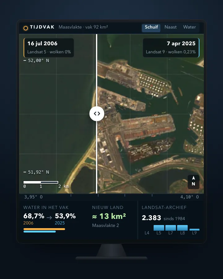
Find cloud-free summer images of Almere or the Maasvlakte, ten years apart. Put them side by side or make an animation.
The Netherlands in 1972
The oldest scenes come from Landsat 1, with 60-metre pixels. Coarse, but enough to follow the broad outline of the country.
Heat in the city
The landsat-c2l2-st collection gives surface temperature. Compare stony neighbourhoods with parks on a hot summer day.
Forty years of green
Compute NDVI from the red and near-infrared bands for every summer since the 1980s and follow an area through time.
How to process it4 steps
Search the USGS catalogue
Searching needs no account. Sort with sortby=-properties.datetime (with 'properties.' in front) and use fields to drop assets and links.
https://landsatlook.usgs.gov/stac-server/collections/landsat-c2l2-sr/items?bbox=4.7,52.2,5.1,52.5&sortby=-properties.datetime&limit=3&fields=id,properties.datetime,properties.eo:cloud_cover,properties.platform,-assets,-links,-geometry
Filter on clouds
Use query with eo:cloud_cover. Over Amsterdam there were twelve scenes with less than 10 percent cloud in summer 2022.
https://landsatlook.usgs.gov/stac-server/search?collections=landsat-c2l2-sr&bbox=4.7,52.2,5.1,52.5&datetime=2022-06-01T00:00:00Z/2022-08-31T23:59:59Z&query=%7B%22eo:cloud_cover%22:%7B%22lt%22:10%7D%7D&limit=5
Download without an account via Planetary Computer
USGS requires a login, even for a thumbnail. Microsoft Planetary Computer offers the same Collection 2 Level-2 with an anonymous token, but lags a little behind.
https://planetarycomputer.microsoft.com/api/sas/v1/token/landsat-c2-l2
Read only what you need
The bands are 30-metre Cloud Optimized GeoTIFFs. Use rasterio or rioxarray to read only the red and near-infrared (nir08) bands for your area.
Interesting combinations


How much has a municipality been paved over since 1985?
Clip the images per year to the municipal boundary and count pixels with a low NDVI.

A longer series with more detail
Use Landsat for the years before 2015 and Sentinel-2 after. Mind the difference in pixel size.
Similar sources
- Copernicus Sentinel-2
Sharper (10 metres) and more frequent, but only since 2015.
 NASA GIBS and Worldview
Ready-made daily images as a map layer, coarser and without raw bands.
- MPMicrosoft Planetary Computer, Landsat Collection 2 not in the index yet
The same Level-2 data, downloadable without an account, about a week later.
What to watch out for
- USGS login
Searching is open, but every USGS download (including the thumbnail) redirects to the login page. On Amazon S3 the bucket is 'requester pays'.
- Clouds
In summer 2026 Landsat 8 and 9 passed over Amsterdam about every four days, but it was often cloudy. Filter on eo:cloud_cover and check the images yourself.
- Stripes in Landsat 7
Since late May 2003 every Landsat 7 scene misses strips, about 22 percent of the image. Prefer Landsat 5 or 8 for those years.
- Not every year equally good
The oldest scenes have 60-metre pixels and four bands. Level-2 (corrected for the atmosphere) only starts in August 1982.
APISTAC 1.0.0 · read 16 Oct 2026
Searching is anonymous. The files themselves require an account (stated in the collection). from the description
scenes tested
GeoJSON (zoekresultaten)
Base URL
https://landsatlook.usgs.gov/stac-server
Endpoints 3
- GET
/collections/landsat-c2l2-sr/itemsscenes in this collection, with bbox, datetime, limit - GET/POST
/searchsearch across collections, with filter (CQL2), sortby and fields - GET
/collections/landsat-c2l2-sr/queryablesfilterable fields
Filtering from the description
CQL2 (text or JSON) on the queryables
Parameters 6
bbox | lon/lat box: west,south,east,north | platform |
datetime | date or period, e.g. 2026-06-01/2026-08-31 | platform |
limit | per page; next via link rel=next | platform |
sortby | sorting, e.g. -datetime (newest first) | from the description |
filter | CQL2 filter on the queryables, e.g. eo:cloud_cover < 10 | from the description |
fields | return only these fields | from the description |
Limits and pitfalls
- sortby=-datetime gives a 400 ('No mapping found for [datetime]'); use sortby=-properties.datetime (15 Oct 2026). tested
- fields=id,properties.datetime does not drop assets and links; add -assets,-links. That saves about 22 KB per scene. tested
- Filter on cloud cover with the query extension: query={"eo:cloud_cover":{"lt":10}}. A text filter (filter=eo:cloud_cover<10) gave an error; filter expects CQL2 JSON here. tested
- Files via https://landsatlook.usgs.gov/data/ redirect to the USGS login page (ERS). Microsoft Planetary Computer issues an anonymous token for the same data. tested
Try it HTTP 200 · 840 ms · 15 Oct
https://landsatlook.usgs.gov/stac-server/collections/landsat-c2l2-sr/items?bbox=4.7,52.2,5.1,52.5&sortby=-properties.datetime&limit=3&fields=id,properties.datetime,properties.eo:cloud_cover,properties.platform,-assets,-links,-geometry
{
  "type": "FeatureCollection",
  "numberMatched": 4630,
  "numberReturned": 3,
  "features": [
    {
      "stac_version": "1.0.0",
      "bbox": [
        1.888558990141831,
        50.61142258385865
      ],
      "id": "LC08_L2SP_199024_20261011_20261015_02_T1_SR",
      "collection": "landsat-c2l2-sr",
      "type": "Feature",
      "properties": {
        "datetime": "2026-10-11T10:40:04.812085Z",
        "eo:cloud_cover": 37.87,
        "platform": "LANDSAT_8"
      }
    },
    {
      "stac_version": "1.0.0",
      "bbox": [
        2.4822383108926482,
        52.01759582018972
      ],
      "id": "LC08_L2SP_199023_20261011_20261015_02_T1_SR",
      "collection": "landsat-c2l2-sr",
      "type": "Feature",
      "properties": {
        "datetime": "2026-10-11T10:39:40.921044Z",
        "eo:cloud_cover": 18.97,
        "platform": "LANDSAT_8"
      }
    }
  ],
  "links": [
    {
      "rel": "next",
      "title": "Next page of Items",
Shortened response, saved at harvest time. Click the URL for the real, current response.
Read from collection: bands, coverage, licence, access · fields you can filter on · what the search API supports (conformsTo). Labels: from the description stated in what the api itself publishes. tested from our own small call. platform applies to every api on this platform, per its documentation. experience learned while building open data index.
How to fetch it
curl "https://landsatlook.usgs.gov/stac-server/collections/landsat-c2l2-sr/items?bbox=4.7,52.2,5.1,52.5&sortby=-properties.datetime&limit=5&fields=id,properties.datetime,properties.eo:cloud_cover,-assets,-links,-geometry"
Used by
- LandsatLookSearch and view Landsat images in the browser (USGS)
- EarthExplorerUSGS download portal for satellite images and aerial photos
More from USGS in our index
4 datasets in Copernicus Data Space (STAC). These changed most recently.
More in this topic



See how this page is built
bron: landsat
blokken: []
secties:
  - ideeen
  - verwerken
  - koppelingen
  - vergelijkbaar
  - beperkingen
  - code
  - gebruiktDoor
cache:
  tag: bron:landsat
  ververs: na statuscheck, als de bron nieuwer is
statuscheck:
  methode: "STAC: nieuwste Level-2-opname boven Amsterdam"
  verwacht: dagelijks
Source: content/bronnen/landsat.yaml · Markdown